Explore the classic Everest Base Camp Trek via Jiri with Asiana Treks and Tours, a journey that blends cultural discovery with Himalayan adventure. Starting in the vibrant streets of Kathmandu, the trek winds through picturesque villages, lush forests, and high mountain passes, offering panoramic views of peaks like Mount Everest and Ama Dablam. Travelers experience Sherpa culture in Junbesi and Namche Bazaar, traverse the challenging Lamjura La Pass, and finally reach the awe-inspiring Everest Base Camp. With rest days for acclimatization and optional local hikes, this 21-day journey promises an unforgettable blend of adventure, natural beauty, and cultural immersion in the heart of Nepal.
The classic Trekking route to Everest Basecamp via Jiri is the old route that followed the historic Jiri route of Sir Edmund Hillary's and Tenzing Norgay's historic footsteps. This path is not only rich in history but promises an adventure of a lifetime.
Your journey commences with a captivating drive from Kathmandu to Jiri. As you wind through this scenic route to Dolakha Jiri, you'll be treated to breathtaking landscapes and encounter charming villages along the way. This route's gradual altitude gain makes it special, which ensures better acclimatization and minimizes the risk of altitude sickness.
Trekking through this route provides a remarkable opportunity to immerse yourself in the local culture. You'll traverse diverse villages, Bhandara Sete, Junbesi, and Lamjura, pass with the friendly locals, and gain insight into the unique Sherpa way of life.
The lower sections of the trek are a feast for the eyes, featuring lush forests, terraced fields, and rolling hills. This contrast to the high-altitude terrain further enhances the beauty of your journey.
Take a well-deserved break in Namche Bazaar, a bustling Sherpa town that offers a chance to acclimate and fantastic shopping opportunities With breathtaking mountain views that will leave you spellbound.
After Namche, we are toward Tangboche, Pangboche, and Dingboche Labuche. As you approach Everest Base Camp, you'll find yourself in a surreal setting, surrounded by towering peaks, the famous Khumbu Icefall, and an unmistakable spirit of mountaineering that hangs in the crisp mountain air.
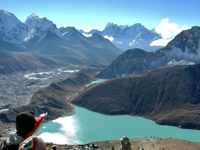
Climb Kala Patthar, a vantage point that rewards you with a panoramic view of the mighty Mount Everest and the magnificent Himalayan peaks Pumari Lotshe and many other peaks encircle it.
To wrap up your incredible journey, you'll return via Lukla, where you can catch a flight back to Kathmandu. This smooth transition from the mountainous terrain to the city's hustle and bustle provides a fitting conclusion to your adventure.
The Mt Everest to via Jiri route offers a unique perspective on the Everest region. It seamlessly blends cultural immersion, gradual acclimatization, and historical significance to create an unforgettable trekking experience. Whether you're a seasoned trekker or a first-time adventurer, this well-rounded route is ideal for those who want to do something extraordinary in adventure and exploring nature.
Everest Base Camp trek via Jiri itinerary:
Asiana Treks has the perfect Everest Base Camp trek via jiri, itinerary for travelers who desire to explore Nepal with moderate physical fitness. You'll discover the best places for breathtaking views from the city to the countryside. Experience the contrast of cold nights at EBC to a stunning view of the mountain wall, an unforgettable lifetime journey.
Everest Base Camp Trekking via Jiri Distance:
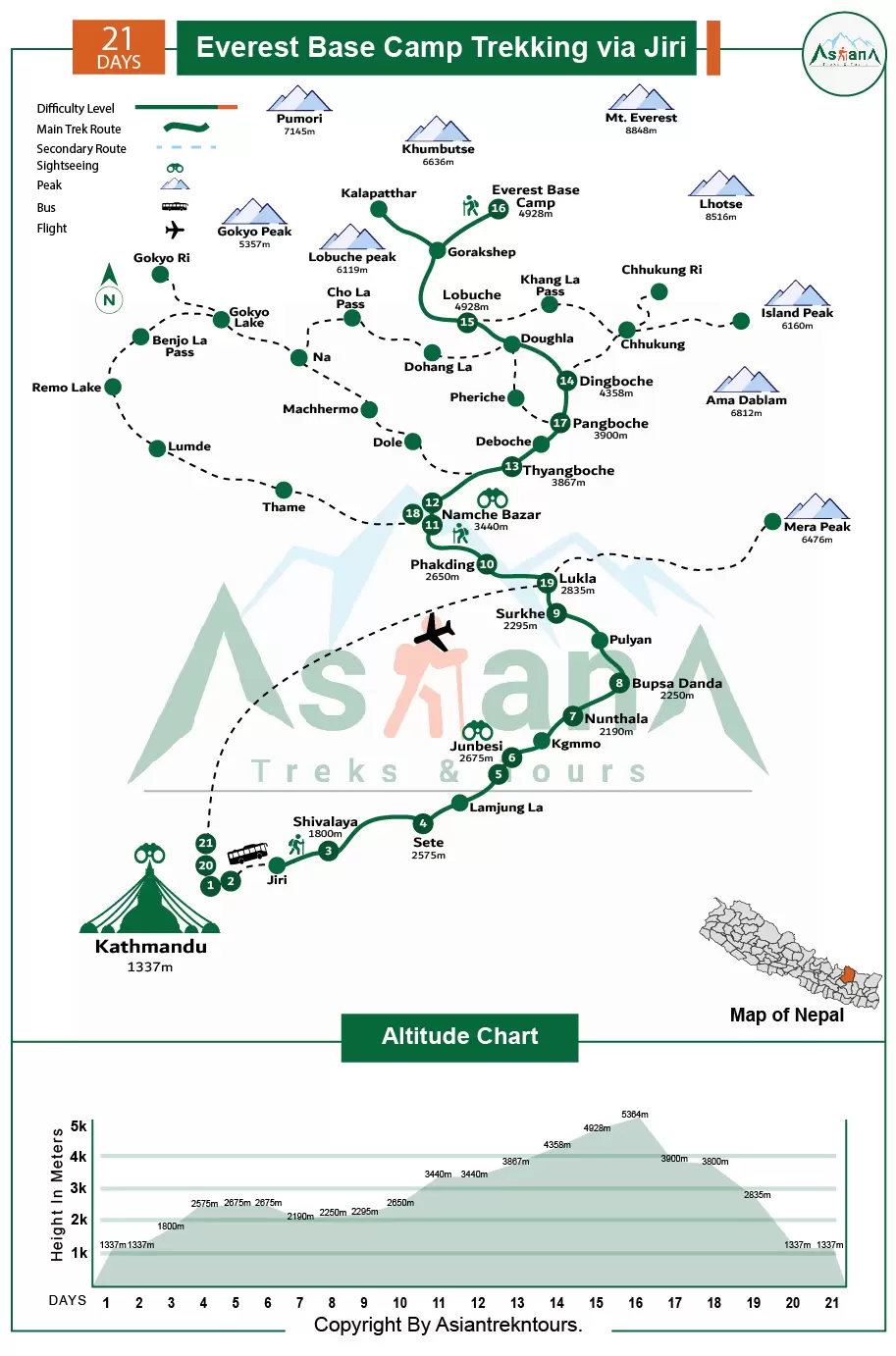
The Everest Base Camp trekking via Jiri takes 21 to 25 days, with 4 to eight-hour walking days, and is approximately 190 km, or 120 miles, depending on the itinerary and acclimatisation day.
Everest Base Camp Via Jiri Trekking route:
The Everest Base Camp Trekking via Jiri route showcases awe-inspiring natural beauty. Starting in lush valleys with terraced fields and traditional Sherpa. Villages, the journey unfolds amidst the Himalayan foothills. Rhododendron forests bloom in spring, accompanied by cascading waterfalls and snow-capped peaks. Traversing wildflower meadows and crossing suspension bridges over mountain streams, the landscape evolves as you ascend. Approaching Everest Base Camp, rugged terrain and glacial moraines dominate, leading to panoramic views of towering peaks. The Trek promises unforgettable moments, whether you're a seasoned trekker or novice adventurer, offering an unparalleled journey through Earth's most breathtaking landscapes and top of the world.
Everest Base Camp trekking via Jiri price:
Our package tour ensures reliability in terms of cost, itinerary, and overall experience. The Everest Base Camp trek via Jiri typically ranges from US$1800 to 2400, depending on group size, service level, guide and porter services, transportation preferences, and accommodation category in Kathmandu. This cost estimation is subject to the types of trekking gear and accommodation preferences.
Everest Base Camp trekking via Jiri Height:
The Everest Base Camp trekking via Jiri starts starts with a drive to Jiri at 1,900m and a trail walk to Shivalaya (1,770m), and then to Sete (2,575m). After Sete, you will continue to Junbesi at 2,675m and then drop down to Nunthala at 2,190m. The walk continues to Bupsa Danda at 2,250m and Surkhe at 2,295m before reaching Phakding at 2,650m. After that, you will trek up to Namche Bazaar at 3,440m, the busy Sherpa's town. Then the trek moves on to the famous Tengboche Monastery at 3,867m followed by a visit to Dingboche at 4,358m for the rest day. Then the trek heads to Lobuche at 4,928m and then to Gorak Shep at 5,160m. From Gorak Shep, the trek continues toward Everest Base Camp at 5,364m.
Major villages of Everest Base Camp via Jiri Trekking:
The major Sherpa villages along the Everest Base Camp Trekking via Jiri route via Jiri are Lukla, Deurali, Sele, Junbesi, Nunthala, Bupsa Danda, Surkhe, Lukla, Phakding, Namche Bazaar, Tayangboche, Dingboche, Pangboche, Lobuche, Gorakshep and Return from the same route and follow the same path back to Lukla. These villages are significant landmarks and offer scenic beauty and accommodation options along the Everest Base Camp Trekking route.
Best Viewpoints Everest Base Camp Trekking via Jiri:
These viewpoints provide unforgettable experiences, highlighting the beauty of the Everest Base Camp Trek. Everest Base Camp Trek Via jiri offers breathtaking viewpoints, showcasing stunning panoramas of the surrounding Himalayan peaks. Here are the critical views along the route:
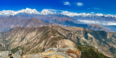
On a clear day, board your Flight to Lukla or Ramechhap, ensuring a seat on the left-hand side for a breathtaking view of the uncountable Himalayan peaks, from the Langtang Himalayan range to the majestic Mt Everest.
Hillary Bridge: After halfway from Hillary Bridge to Namche, you will first glimpse the majestic Everest view.
Hillary Park Sagarmatha Head Headquarters: At the top of Namche Headquarters of Sagarmatha National Park, Hillary Park, you have a stunning surrounding view of Many Himalayan ranges, including Mt Everest.
Everest View Hotel: From Everest View Hotel, you can enjoy unparalleled vistas of Everest and neighboring peaks,
Tangboche, Pangboche, Deboche: Traverse picturesque villages, each providing unique perspectives of the towering giants en route to Everest Base Camp.
Thukla: On the way from Lobuche to Thukla, soak in the stunning views of jaw-dropping Himalayan peaks.
Kala Patthar: Summit at dawn for an unrivaled panorama of the Everest region, witnessing the mountains come alive in a symphony of colors as the sun rises.
Each viewpoint leaves an indelible mark on your soul, ensuring the journey back to Lukla reminds you of the awe-inspiring vistas encountered throughout your Trek.
Everest Base Camp (ABC): The ultimate destination, commonly listed as 5,550 m (18,209 ft). Meters offers unparalleled views of
Flora and Fauna in the Everest Basecamp Trekking via Jiri :
Everest Basecamp Trekking via Jiri is also in Sagarmatha National Park. It deserves many different flora and fauna, Where pine and hemlock forests are found at lower altitudes, and fir, juniper, birch, rhododendron, scrub, and alpine plants thrive at higher elevations. Sagarmatha National Park is inhabited by a diverse range of animals, like red panda, snow leopard, musk deer, Himalayan tahr, marten, Himalayan mouse hare (pika), and over 118 bird species, such as the Impeyan pheasant, snow cock, blood pheasant, and red-billed cough.
Festivals and Culture of Everest Base Camp Trekking via Jiri:
The Everest Base Camp trek via Jiri offers a cultural immersion into Sherpa traditions. A highlight is the Dumji and Mani Rimdu Festival at Tengboche Monastery, held annually in October or November. This vibrant celebration features sacred dances and colorful ceremonies, providing insight into Sherpa culture.
Buddhism, a central pillar of Sherpa life, is beautifully woven into the Trek's fabric. It's evident in the monasteries, prayer flags, and Mani walls that dot the route. Visitors are not just spectators but can actively participate in Buddhist rituals, fostering a deeper understanding of Sherpa spirituality and their profound connection to nature.
In their harmonious coexistence with nature, Sherpas practice sustainable living with eco-friendly methods like using yak dung as fuel and waste management. These practices, born out of necessity and deep respect for the environment, are a testament to the Sherpa's ingenuity and their role as responsible stewards of the land. It's a practice that inspires respect and admiration.
People and hospitality Everest trek via Jiri:
Nepal is a country where warm hospitality and incredible values are not just a custom, but a deeply ingrained part of its culture. Whether you're a foreign visitor or a local, you're greeted with open arms, friendly smiles, and a radiant manner. This tradition of hospitality, deeply rooted in Hinduism, Buddhism, and traditional customs, sees guests as blessings and treats them with utmost respect, generosity, and kindness.
The Sherpa people, an indigenous ethnic group with a unique blend of Tibetan Buddhism and ancient Bon rituals, are the epitome of these values. Residing in the upper Khumbu area, they welcome guests with a distinct warmth and an unwavering spirit of hospitality, marked by their renowned honesty and loyalty.
Advantage book with Asiana Treks and tours:
Trek Booking:
Asiana Treks and Tours is the best and most trusted trek and tour company operator authorized by the Nepal government. We require a 10% advance payment to book your trip, and you'll need to send us a copy of your passport, photos, travel insurance, and flight details as soon as you book a tour with us. You can use bank transfer, or any other way like Western Union, or online via our website, which is easy. The remaining trip cost can be paid upon arrival in Nepal. We offer last-minute bookings, but changes may occur due to circumstances like bad weather.
Transportation for Everest Basecamp trekking via Jiri:
Asiana Treks and Tours Organizes all transportation logistics from start to end, according to our group size and agreement, including pickups and drops of service to flights between Kathmandu and Lukla for ground transportation for World Heritage site tours. Our services for all groups ensure convenient travel arrangements, whether a World Heritage tour or Flight tickets, and are tailored to the group, prioritizing safety, comfort, and efficiency. We aim to provide the best and most enjoyable travel experience, meeting the highest standards of safety and comfort.
Trekking Start:
Your Everest base camp trek via Jiri begins with a warm welcome in Kathmandu. Our team member will greet you at Tribhuvan International Airport. We'll escort you to your hotel in a private vehicle, ensuring a comfortable and hassle-free start to your adventure. This will set the tone for a memorable journey.
If you miss the regular trip briefing, don't worry. We'll provide it at a convenient time before departure, or before a World Heritage tour the following morning or the next day; we'll then proceed to the airport flight to Lukla or drive four 4-hour Manthali and Flight to Lukla.
Currency Exchange:
The Nepalese rupee is Nepali currency, and 1 USD is approximately 130 NPR. Only NPR is accepted in Nepal, so it's best to bring cash to facilitate transactions. Banks and ATMs in Kathmandu provide currency exchange services but note that most banks prefer new, crisp notes.
Our Team:
The Asiana Treks and Tours team is professional, reliable, and responsible. They are well-trained, friendly, radiant, and fluent in English. You can feel comfortable sharing anything with them. They are experts in local culture, history, vegetation, food, accommodation, weather conditions, and first aid medication. They are also environmentally conscious and respect the rights of animals.
However, please do not provoke them for personal gain during the trip. While you can enjoy your holiday with them, we kindly request that you do not try to change their customs, beliefs, religion, culture, or traditions.
We and our staff are committed to making your adventure trip unforgettable memories of a lifetime journey in Nepal.
Guide and Porter Arrangement:
Our company, Asiana Treks and Tours, focuses on responsible tourism in Nepal. We make sure our guides and porters are well-trained in Trekking and mountaineering. They know a lot about the areas we go to, including geography, history, customs, and culture. We train them regularly in safety, first aid, and environmental conservation. We follow guidelines to treat our porters fairly, providing them with good pay, accommodation, and meals during treks. Our guides and porters are essential team members, and we appreciate their hard work. When you trek with us, you support ethical tourism in Nepal, making your trip meaningful and memorable.
Asiana Treks and Tours prioritizes your safety and enjoyment. Our knowledgeable guides, reliable equipment, and safety measures ensure a great trekking experience in Nepal.
Porter, Luggage, and extra Luggage storage:
We cover the cost of porters for your Luggage, but the maximum weight limit is 12 kg per person. Each porter carries Luggage for two trekkers; please share a duffle bag with another. Our porters will carry up to 25 kg each. If you need a porter for yourself, we can arrange that. We also recommend carrying a small backpack for your valuables and important documents. You can leave extra Luggage at our office for free and at a hotel in Pokhara, Namche, etc.
Accommodation:
Accommodation during the Everest Basecamp Trek via Jiri varies. Along the trekking route, you'll stay in guest houses, commonly known as teahouses. These basic lodges offer rooms, dining areas, and toilets. The quality of guest houses varies but remains affordable and convenient for trekkers. Rooms typically have twin or bunk beds and shared bathrooms, and blankets and pillows are available. Our company can offer a sleeping bag if you don't have one. You'll spend nine nights in lodges along the trekking route and three nights in a hotel in Kathmandu. Some places and lodges have attached bathrooms, while others offer simple yet clean rooms with shared facilities. We can arrange a solo trekking service if you're traveling solo. In high season and particular areas, availability may be limited for you, although we try our best. In Kathmandu or Pokhara, your hotel room will have excellent amenities, including TV, 24/7 hot water, electricity, and laundry service.
Meals during the trip:
Eating well is essential since the EBC Trek takes via Jiri you through the Himalayas. You'll have plenty of nutritious meals in the trekking regions, although the options won't be as varied as in the cities. You'll get fifteen breakfasts, eleven lunches, and ten dinners during the Trek. The menu includes local, Asian, and Western dishes, but it gets more straightforward as you climb higher. Try popular Nepali foods like lentils, rice, curry, dumplings, noodles, Spagaties, and many more. We highly recommend eating fresh vegetables and drinking liquids like green tea, lemon tea, hot lemon, ginger tea, and garlic soup, especially at high altitudes. While non-vegetarian options are available during the Trek, we suggest avoiding them for hygiene reasons. It's also best to steer clear of dairy, cheese, alcohol, caffeine, and hot chocolate. Personal expenses like alcoholic drinks, extra beverages, and cafes aren't included in the package.
Guest House Facilities:
Guest houses are familiar places to stay while trekking in Nepal. They're simple lodges with rooms, eating areas, and toilets. Guest houses vary in quality but are affordable and convenient for trekkers. They offer a cozy place to rest after walking and serve Nepali and international food. Rooms usually have twin or bunk beds, and bathrooms are shared. They provide blankets and pillows. Our company offers sleeping bags, but it's a good idea to bring one for extra comfort.
Safe Drinking water:
Water is a great source of Nepal. Nepal is the second country in the world in terms of water sources after Brazil. According to the Nepal government, only 27% of people here have clean drinking water. You can buy mineral water in teahouses, but it is expensive; Locals people do not prefer plastic bottles in some trekking areas, but there are some safe drinking water stations where you can refill your bottle. However, we recommend carrying Steripen, iodine drops, water purification tablets for safe drinking, and refillable water bottles for boiled or filtered water. We strongly advise not to drink from taps, wells, and rivers in trekking areas. However, in all the city areas, Mineral water is available at a reasonable cost everywhere.
Extra Personal Expenses:
Your Trip covers most expenses during the Trek; you'll need to spend money on extra accommodations and meals in Kathmandu, souvenirs, and beverages. We estimate about USD 15-25 per trekking day for miscellaneous expenses. However, personal expenses depend on your Income, habits, and style.
Toilet Facilities in Everest Base Camp Trekking Via Jiri:
Most teahouses have Western-style flush toilets during mountain treks, especially at lower elevations. But as you go higher, find simple squat toilets along the trails and teahouses at higher altitudes. These toilets usually have water or toilet paper, but it's a good idea to bring your toilet paper just in case. You can also use restrooms at nearby teahouses or find a private spot along the trekking routes.
Internet Connectivity:
While trekking in the Himalayan region of Nepal, connecting with your family and friends is also a good idea. You can find internet access at teahouses and lodges, but it might be extra minimal cost. The signal might be weak because of the remote location. You can also get internet access using a local SIM card and data packages available at Kathmandu airport or nearby shops in Thamel and Pokhara. You'll have a passport-sized photo and a copy of your passport to get a SIM card. It's a good idea to compare prices and data packages from telecom companies like Ncell and Nepal Telecom before buying. Knowing about teahouse connectivity. Our guide will suggest connections for you.
Electricity voltage and plugs:
However, 95 % of Nepali people have access to electricity as of May 29, 2023. almost popular trekking routes, teahouses, and lodges have electricity. However, some isolated and solo trekking tea houses in the jungle don't have electricity; most tea houses let travelers charge for their devices for a small fee. The average electrical voltage in Nepal is 230 volts, with plug types like Type C, Type D, and Type M. Travellers should bring a suitable adapter and, if needed, a voltage converter for their electronic devices.
Communication:
The guest houses in the trekking regions have internet access. You could buy a SIM card at Tribhuvan International Airport Kathmandu and Namche. However, the signal may need to be more assertive at high altitudes. Our office keeps in touch with all trekking teams via the trek guide at least once daily to ensure everything goes as planned.
Trip Extension:
Suppose you have extra days in Nepal after the Trek. In that case, we can arrange a tour, overnight stay at Nagarkot Balthali or any other place around Kathmandu and Chitwan, jungle safari, paragliding, rafting, canyoning, or other treks. Do not hesitate to Inform us. We will create the best for you.
Trek Difficulty:
The Everest Base Camp trek via Jiri presents a moderate and challenging yet enriching adventure. Your enjoyment of the trip will largely depend on your level of fitness. We recommend building stamina at least two weeks before the Trek. Activities include jogging, running, swimming, or taking long hikes for the journey ahead.
Completing this Trek is achievable even if you're a beginner, although you must maintain a reasonable fitness level. Prior trekking experience can be advantageous, though it is optional. All you need is the readiness to hike steadily for 4-8 hours, navigating tricky terrain.
Suppose trekkers have pre-existing medical conditions, such as lung or heart diseases. In that case, they are advised to consult their physician before booking the Trek to ensure their safety and well-being throughout the journey.
Trip Safety:
We highly give top priority. We provide experienced guides with first aid kits and necessary safety gear to ensure a safe hand. Our team monitors weather and trail conditions and takes precautions to avoid risks. Before starting the Trek, we discuss the trip to provide a clear understanding and ensure a reliable experience.
Group & Private Treks:
We organize many group and private treks simultaneously, with discounts available for larger groups. Every group will have a trekking guide and porters. Regarding larger groups, we provide an assistant guide. Our team ensures a safe and enjoyable trekking experience for all participants.
About solo traveler:
If you're a solo traveler, please get in touch with us to confirm departure dates before booking. You can tell us via call, WhatsApp, or email. We have listed upcoming departure dates for your convenience. Feel free to share the trip details with friends and family.
Notes: Please be aware that the itinerary may change due to weather or other factors, and we'll adjust it accordingly for the group's safety and enjoyment. We look forward to guiding you through the stunning landscapes of the Annapurna region and ensuring a memorable trekking experience.
Responsible Travel:
We prioritize responsible travel to minimize environmental impact and support local communities. We collaborate with organizations like the Kathmandu Environmental Education Project (KEEP) to promote eco-friendly practices in trekking regions.
Gratitude:
Graduate or tipping is appreciated in Nepali culture and reflects the quality of service provided. You decide how much to tip, but we recommend tipping as a group at the end of the trip.
End of Trek:
On the eleventh day, you'll take a bus from Pokhara back to Kathmandu, which takes about seven hours. Alternatively, you can fly from Pokhara to Kathmandu for an extra fee. In the evening, we'll host a farewell dinner in Kathmandu.
Departure:
On the day of your departure flight, we'll come to pick you up from your hotel and transfer you to Tribhuvan International Airport. We hope you enjoyed the Nepal trek and will consider returning for more adventures in Nepal.
Feedback:
After you complete the Everest basecamp trek via Jiri, we'll organize a farewell dinner in Kathmandu and present you with a trekking achievement certificate. After the dinner, you can provide feedback about the Trek on travel portals.
Last-Minute Booking:
If you can't book in advance, we offer last-minute bookings. Last-minute booking offers are available but may cost slightly more than regular departure dates. Those opting for last-minute bookings must pay an additional 7% of the total trip cost on our website. While we strive to make last-minute requests, we try our best to accommodate according to your last-minute booking holiday.
Special Note: Please remember that sometimes unforeseen circumstances, such as inclement weather or unavailable lodging, may cause the schedule to be changed. Your trip guide will design a fresh schedule based on the group's interests in such circumstances.
Best time to travel to Nepal:
Nepal is a country of differences with various landscapes, including towering mountain ranges, lush forests, and a vibrant cultural heritage. The best time to travel to Nepal depends on your preferences and the type of excursions or events you intend to participate in. Generally, Nepal has four distinct seasons, each with unique charms and challenges.
Autumn Season: September to November is Nepal's best time for trekking and outdoor activities. Clear skies, pleasant temperatures, and festivals like Dashain Tihar and Chhat make this period ideal for experiencing Nepali culture.
Winter Season: Cold temperatures start in late November or early December, but clear skies suit budget travelers. Lower-elevation treks and skiing/snowboarding in ski resorts are popular activities.
Spring Season: From late February to May, warmer temperatures make it perfect for trekking. Rhododendrons bloom, adding to the scenic beauty. Celebrations like Holi and Buddha Jayanti occur during this time.
Summer Season: Monsoon rains from June to August make trekking challenging, but it's a great time to experience lush greenery and agriculture. Ideal for peace seekers and cultural tours of cities accessible by road.
Fitness and Training:
Trekking and climbing in Nepal's high-terrain Himalayas require physical fitness and training for a safe journey. Trekking involves walking long distances, sometimes for hours daily, over different terrain and at high altitudes. To build stamina and prepare the body, it's best to start fitness activities a few months before the trip, including cardio, strength, and endurance training.
Your journey to Nepal can be safe and successful with physical fitness, training, and preparation. Be aware of the risks and challenges, and take necessary safety measures for a fun and secure trip.
Tims and Permit :
To enter Everest Basecamp Trekking Via Jiri, you need three different kinds of permits for the Everest Base Camp Trek: the Khumbu Pasang Lamu Rural Municipality Permit, the Sagarmatha National Park Permit, and the TIMS card.
Khumbu Pasanglamu Rural municipality permit is necessary to enter the Khumbu region. It can obtained in Lukla or Monjo. For foreigners, it costs NPR 2000 (USD 17) per person for the first four weeks and NPR 2500 (USD 25) afterward. Remember, you can't get this permit in Kathmandu.
TIMS Card The TIMS card is essential for guides, porters, and clients in emergencies. It costs USD 20 and is issued by TAAN Nepal.
Sagarmatha National Park entry permit, 3333Rs Per person, Rs 26 US$ in equivalent.
Gaurishanker Conservation Area Project Entry Permit fee of NRS 2,000.Rs 17 US$ in equivalent. Before starting your trek, you can obtain a permit from the Nepal Tourism Board’s office in Kathmandu.
Entry permit and requirements (About Visa)
To visit Nepal, you need a valid passport and a visa. You can quickly get an arrival visa at entry points or Kathmandu's Tribhuvan International Airport. However, some people need a permit before they come, so it's good to check with the nearest Nepalese embassy.
Some nationalities that don't get visas from immigration entry points in Nepal are Nigeria, Iraq, Ghana, Afghanistan, Swaziland, Zimbabwe, Somalia, Palestine, and Ethiopia.
There are three types of visas as in the table below:
15 days, 30 days, or 90 days. The cost varies from $30 to $125 depending on how long you want to stay.You can pay in US dollars or other significant currencies, sometimes even Nepalese rupees.
If you're coming for business, you can get a suitable visa for up to 5 years. The fee depends on how much money you're investing. If you invest less than 10 million Nepalese rupees, it's $35 per month, $400 per year, or $1000 for five years. If you invest more, the fees are lower; if you invest more than 100 million Nepalese rupees, you don't have to pay any fees.
People fromSAARC countries get a free 30-day visa.Indians don't need a visa, but they must show ID, like a passport or citizenship card. Make sure your passport is valid for at least six months. And it's a good idea to have travel insurance which covers medical treatment and emergency evacuation.
Some places in Nepal require a separate permit to visit. Our TIMS card and Permit fee section provides more details.
Travel Insurance:
When traveling to Nepal, travel insurance that covers medical emergencies, accidents, and cancellations is essential. We recommend a policy of at least USD 100,000 coverage to provide financial security in case of unexpected events such as altitude sickness or accidents. Please Choose an insurance provider with a good reputation and ensure your policy covers chopper rescue costs in high-altitude areas. Take a copy of your insurance policy and emergency contact details for peace of mind during your trip.
Trip Safety:
We highly give top priority. We provide experienced guides with first aid kits and necessary safety gear to ensure a safe hand. Our team monitors weather and trail conditions and takes precautions to avoid risks. Before starting the trek, we discuss the trip to provide a clear understanding and ensure a reliable experience.
Guide and Porter Arrangement:
Our company, Asiana Treks and Tours, focuses on responsible tourism in Nepal. We make sure our guides and porters are well-trained in trekking and mountaineering. They know a lot about the areas we go to, including geography, history, customs, and culture. We train them regularly in safety, first aid, and environmental conservation. We follow guidelines to treat our porters fairly, providing them good pay, accommodation, and meals during treks. Our guides and porters are essential team members, and we appreciate their hard work. When you trek with us, you support ethical tourism in Nepal, making your trip meaningful and memorable.
Asiana Treks and Tours prioritizes your safety and enjoyment. Our knowledgeable guides, reliable equipment, and safety measures ensure a great trekking experience in Nepal.
Packing Checklist:
When planning a trip to Nepal, packing the right gear is crucial for a successful journey. This includes clothing, equipment, and accessories tailored to your trek and the time of year. If you're trekking, pack light unless you're hiring a porter. Consider renting or buying gear in Nepal to save space. Ensure your equipment is high-quality and in good condition to avoid problems in the mountains. Take our suggestions to prepare your baggage correctly. Lastly, double-check the weather forecast and ensure you have all the necessary items for a safe and comfortable trip.
Altitude Sickness and Acclimatisation:
Altitude sickness is common among hikers in Nepal's Himalayan Region. It happens when the body doesn't get enough oxygen at higher elevations, causing headaches and dizziness. Acclimatisation is essential to prevent this. It means gradually getting used to higher altitudes by resting, drinking fluids, and ascending slowly. Spending an extra day at lower elevations before going higher is the best way to avoid altitude sickness. Hydration is the main issue during trekking to prevent dehydration, which can worsen altitude sickness. Drinking plenty of water, tea, and soup can help. Trekkers can also take medicines like acetazolamide or dexamethasone to relieve symptoms, but it's best to consult a doctor first. Proper acclimatization techniques, like "climb high, sleep low," and staying hydrated, can reduce the risk of altitude sickness. Booking with an experienced guide can ensure you get the right advice and help during your trek.
History of Lukla airport:
In 2008, Lukla Airport was bestowed with a new name: Tenzing-Hillary Airport, a tribute to the first people to conquer Mount Everest, Tenzing Norgay Sherpa and Sir Edmund Hillary. This airport, with its runway measuring a mere 527 meters long and 30 meters wide, is a testament to human ingenuity and the spirit of adventure. Its unique uphill slope of almost 12% aids planes in slowing down during landing. The airport was established in 1964, and its runway was paved in 2001, marking a significant milestone in aviation history, situated at 2860 meters.
Lukla Flight and Weather:
The Lukla flight, including the famous Everest Base Camp trek via Jiri, is essential for treks to the Everest Region. However, weather in the area can cause flight delays or cancellations, impacting your plans. The flight is known for its thrilling experience due to challenging terrain and unpredictable weather.
Lukla airport is at 2860 meters altitude, and the flight from Lukla to Kathmandu takes about 35 minutes. Flights depend on weather conditions and are often postponed or canceled due to low visibility and weather conditions. The airport's location makes it one of the world's most dangerous, with a short runway on a steep slope that makes it challenging for pilots.
In case of flight cancellations, options include helicopter flights or ground transportation, though this may extend your itinerary. Book flights in advance, during peak seasons, to ensure availability.
Lukla experiences a sub-tropical climate, with temperatures ranging from 5 to 25 degrees Celsius. The best time for the flight is autumn and spring when weather conditions are favorable. Winter brings snowfall and heavy fog, while the monsoon season sees heavy rain and cloud cover, affecting flights.
Planning for potential delays and prioritizing safety when choosing a trekking agency and airline is crucial for a successful journey to the Everest region. We're here to guide you and ensure your visit is memorable, enjoyable, and safe.
About the sensitive zone in Everest Base Camp Trekking Via Jiri:
There are some risky areas to watch out for during the Everest Base Camp Trek via Jiri. This trek is also known as the Everest Kalapatter trek. There are some risky areas to watch out for during the Everest Base Camp Trek Via jiri, especially during snowfall, Mountain Hazards, and heavy rains in winter and March. Please follow the caution of our guides, who are familiar with these risky spots and can help navigate them safely. Travelers sometimes walk without a guide into different terrains and have problems; some have even lost their lives while trekking to Everest Base Camp trek via Jiri without a guide and proper information. parts of trail can be hazardous, especially during snowfall or heavy rains in winter and March. Our guides are familiar with these risky spots and can help navigate them safely. Travelers sometimes run into difficulties, and sadly, some have even lost their lives while trekking to Everest base camp Trekking Via Jiri without a guide and proper information.
Experience the classic Everest Base Camp Trek via Jiri with Asiana Treks and Tours, a 21-day journey that perfectly blends adventure, culture, and stunning Himalayan scenery. Beginning in Kathmandu with a heritage tour, the trek gradually ascends through charming villages, terraced fields, and lush forests, allowing for gentle acclimatization. From the traditional Sherpa settlement of Junbesi to the bustling market town of Namche Bazaar, trekkers enjoy a mix of cultural immersion, scenic landscapes, and rest days for local exploration.
The trail continues past Thyangboche Monastery and Dingboche, reaching the iconic Lobuche and Gorakshep before the ultimate highlight: Everest Base Camp at 5,364 meters. A sunrise hike to Kalapatthar rewards trekkers with breathtaking panoramic views of Everest, Lhotse, and Ama Dablam. The descent via Namche to Lukla and a short flight back to Kathmandu completes the adventure. This route offers a classic, less-crowded approach to the “Roof of the World,” making it ideal for seasoned trekkers and first-timers alike.
Your trip day starts today when you arrive to Tribhuvan International Airport in Kathmandu. Upon your arrival, you will be received by our representative at the airport. He will be carrying a signboard with our company’s name on it. Then you will be transferred to the tour hotel and checked in. A trip briefing will follow later today and the time will be notified to you by the representative who picks you up from the airport. We will come to meet and brief you about the trip at the fixed time. Until then just relax or explore a bit of surrounding.
 Accommodation 3* hotel
  Meals Only Hotel Today
  Max. altitude 1,337m / 4,386ft.
 We take you for a day tour of cultural heritage monuments in Kathmandu valley after breakfast. The tour will give you a mixed insight of history, culture, art, architecture and spirituality of Kathmandu valley. The sites include; Swoyambhunath aka Monkey Temple: The oldest of all sites in Kathmandu valley, Swoyambhunath is an important Buddhist spiritual site having the history over two thousand years old. This site has gained a popular name as monkey temple as this small forested hill is a good habitat for hundreds of monkeys. The visit there will heighten your spiritual and cultural experience. Patan City including Patan Durbar Square: A tour to medieval city of Patan gives you a great insight about ethnic Newari culture, Budhhist spirituality, religious harmony, art and architecture while you stroll around the charismatic alleys taking you to magnificent local community squares known as Bahal and eventually leading you to an incredible medieval palace square. The monuments and skill of the local artisans displayed on those monuments in the square will stun you with their unbelievable charm. Boudhanath Stupa: The largest of its kind in the world, this magnificent stupa is a very important center of faith for the people following Tibetan Buddhism. This place is nice Circular Square with the stunning stupa in the middle of it which spreads a lot of spiritual vibrations around the atmosphere.
Accommodation 3* hotel Meals As per booking Max. altitude 1,337m / 4,386ft. Early breakfast, travel by Bus to Jiri on the busy scenic highway. This is an interesting drive through the foothills of the Himalaya. The road has been greatly improved in recent years. Bus ride from Kathmandu heading towards the Bhote Koshi Valley on the main road to Tibet on reaching at Lamosangu situated merely 30 km from the Tibetan border, the only motorable highway that connects to Tibet. From here the route divert towards east all the way to Charikot, then heads downhill to Tama Kosi River with a brief stop here crossing over the river, the drive climbs on the winding road for another three hours all the way to Jiri, just before Jiri the road descends to the town of Jiri, once a popular busy village and its bazaar, since the construction of the airstrip at Lukla and at Salleri in Solu. The crowds are less than it used to be in the early and late 1980's. Trek to Shivalaya First day trek leads past the bazaar of Jiri on the easy path for a while then the route ascends to a steep climb for an hour or less on the first ridge overlooking view of the nearby landscapes and Jiri town below, from here the walk is on the gradual path passing thorough many farm villages and terrace farms. After a good walk for about two hours, leaving the farmland behind the trail climbs for another hour to a small short pass of Kharubas at 2,712m where there are a Buddhist prayer flags and a chorten. From here a short descend on the grassy slope brings us to our lunch stop on the meadow, after a break here another two hours of downhill walk leads to Shivalaya,
After a good breakfast, start walking at the very end of the village towards east, an hour steep climb brings to a small village of Sangbadanda, from here the walk is quite gradual, passing through many small rural village and forest and then coming to a stream before taking a uphill path through the cool shade of the forest of pine, oaks and rhododendron trees after 3-4 hrs of walk from Shivalaya then reaching at Deurali pass of approx 2,715m. After a stop here, the path descends most of the way for nearly two hours to Bhandar. Bhandar or Chyangma has a mixture of Tamangs and Newars, but are predominantly Sherpa people.
From here onwards the walking will be much cooler, beginning with a steep climb through the beautiful enchanting woods of rhododendron, oaks and pines and then coming to a small settlement of Ghurasey in the midst of a lovely forest, where there are few houses with teahouses, journey continues up to a place where the ridge is marked by a mani-wall the way forks left to reach the pass. In springtime this place will be in a mass of rhododendron in bloom. After reaching the ridge the walk is on the gentle path till we reach a nice clearing with 2-3 lodges just few minutes before the pass. An inviting break here for a while, after a rest at Lamjura a short walk leads to the Lamjura-la pass the highest altitude gain so far before reaching the high Khumbu area. From the pass, the paths descend through a forest of mixed fir and rhododendron all the way to a Sherpa village at Thaktor where it has a huge, intricately carved, mani rock. After reaching the bottom, the trail ahead contours to the north side of the valley, rounding the ridge Junbesi is visible the path descends all the way to Junbesi, this is a large Sherpa village with chorten, monastery and a school built by Sir Edmund Hillary.
An essential rest day, there are many ways one can enjoy the day in Junbesi a stroll in the village, visit the monastery or just relax. For those with an interest in Tibetan Buddism, there is an attractive alternative hike from Junbesi which leads heads north up the west bank of the Junbesi khola until it is possible in just over one hour to cross the river to the east bank and ascend to the village of Mopung. North - west of this settlement, before Pangkarma, is the Gompa of Thubten -cho-ling, a monastery which was established after the Chinese occupation of Tibet. It now has over 100 monks, who are predominantly Tibetan rather than Sherpa and it can be regarded as the most important monastery in the Solu / Khumbu district. The Gompa is headed by Tul-shis-rimpoche himself, regarded as the spiritual leader of Buddism.
Today will be a quite a long days walk to Nunthala, the walking from here is marvelous along the hillside, passing through forests of pine, oak and rhododendron and reaching to a village of Solung danda where you can have the view of Everest in the distance a dark pyramid shaped and other high snow capped mountains of Khumbu, route descends to the valley of Beni khola, which flows from the Dudh kund glacier, beneath the southern flanks of Numbur, Khartang and Karyolung Himal, from this river cross over the bridge then a steep up for half an hour brings to the first house at Ringmo where the road from Salleri lower Solu joins. Walk from here heads up on the gradual path through the village of Rimgmo, leaving Ringmo from the large mani 'prayer' wall, an hour or less steep climb through the pine forest reaches towards Trakshindu pass at 3,070m marked with mani and chorten, a great view of several striking peaks including Kusum Kangguru, Thamersarkhu and Kantega to the north east. On the east side of the pass the path descend all the way to our destination at Nunthala passing through Trakshindu Gompa., which was set up around 1946 by a lama from Thyangboche monastery, this is also a home of the renowned late Babu Chiri Sherpa who climbed Everest 11th times and the fastest man to speed to Everest summit and the only climber who has stayed on top of Everest for more than 21 hours. From Trakshindo walk leads downhill for more than 2 hours through the cool shade of the forest and then coming to Nunthala also known as Manidingma.
Morning journey begins with a descend after leaving the suburb of the village, following the steep downhill slope through the terraces and forest where you can often see Languar monkeys all the way to the suspension bridge over the Dudh Koshi, after a brief moment here crossing over the raging river, our route leads to a gradual winding uphill climb for an hour or more to the Rai settlement at Jubing at 1,675m, the areas around here are fairly warm. From here the path meanders through stands of bamboo near to the houses, walk continues towards Kharikhola 2,200m, a village of predominately Sherpa and Magar inhabitants. After a break here at Kharikhola heading to the next ridge by crossing the river tributaries of the Kharikhola with a steep climb for an hour or more towards a small settlement of Bupsa, perched on the ridge overlooking superb views of the rolling hills and valleys.
From here onwards the air gets much cooler heading nearer to the Khumbu area, walk leads to a climb on the wide meandering path through a mixed forest of oak, rhododendron and the fragment Dhaphne bholua; the Nepalese paper plant, bird life, including pheasant, is abundant along this section of the trail. Our route continues traversing the flank of the Kharte Dande high above the river to a notch in the ridge, the Kharte La 3,880m, walk continues through a small village at Puiyan 2,800m, a nice spot in the middle of the forest. After Puiyan the walk is gentle for couple of hours on the long winding path and rising slowly on the flank of the Sebuk Danda to the Chotok La 2,945m. From this ridge high above towards North West, we can see the Lukla town and its airstrip and the Surkhe village down below, then descending nearly 700 meteres drop to Surkhe, situated just beneath the hills of Lukla, where one can see the airplane flying overhead.
From Surkhe our route diverts westward to join the main trail coming from Lukla, time permitting if some one wish to visit Lukla can do so which will take about two hours of steep uphill climb and can join later at Phakding. Our walk leads to a climb on the winding path, coming to a village at Muse and Ghaikharka after two hours of good walk, from here a gentle climb brings at a place called Choplung where the road from Lukla joins. The walk from here is on the gradual path most of the way, with few ups in between, from Tarhe khola, where you can have a superb view of Kusum-Kangru 6,369m after crossing a short suspension bridge, and a climb brings to the Ghat village, another hour of pleasant walk reaches to Phakding village for the overnight stop.
From Phakding after crossing the suspension bridge over the Dudh-Kosi the walk is pleasant with few short uphill and downhill and re-crossing the same river again, with magnificent view of Thermasarkhu 6,608m, from the village of Benkar, cross the long suspension bridge over the Bhote-Koshi river, after the bridge on this busy trail of trekkers and Ghopkyo and porters, finally reaching at a small village of Monjo after the last 20minutes climb from the stream. Monjo is situated below the magnificent peak of Thermasharkhu and near the entrance of Sagarmatha National Park. After few minutes walk from Monjo, comes to the entrance of Sagarmatha National Park. From here a short descend and a gradual walk brings to the suspension bridge over the Bhote-Koshi river, after the bridge Jorsalle village is reached, the last village before Namche Bazaar is reached, from here the walk is along the winding uphill path all the way to Namche Bazaar, with magnificent view of Kwangde peak and it other sister peaks towards east, with Kusum kangru on the back as you climb higher, view of Mt.Everest- Nuptse wall, Lhotse and the closer view of Taweche peak can be seen all the way up to Thop Danda, where there's a resting stone wall for the porters and trekkers few years ago a teahouse existed here, from here another 1-2 hour walk up brings to the famed Namche Bazaar, the colourful houses are situated in an amphitheatre U shaped bowl.
Suggested activities a short walk uphill to the Sagarmatha National Park Headquarter, a magnificent spot perched on top of Namche Bazaar with breathtaking view of the surrounding snow capped giants and the valleys way down, with an interesting museum with all kinds of information regarding the history of the Himalayas, geographic, culture, mountaineering history and existing information on flora and fauna of this region, afternoon at leisure.
The walk is fairly easy for the first half, after a 20 minutes climb to the top ridge of Namche Bazaar. Once at the top near the park museum the walk follows on the gradual trail with few short up and downs overlooking magnificent view of the great giant snow peaks from Everest, Nuptse, Lhotse, Ama Dablam, Thermasharkhu and Kwangde-ri peak after a pleasant walk of two hours coming to a small place at Shanasa, on this area there is more chances of seeing the beautiful colourful Danphe pheasant (Impeyan Pheasant) national bird of Nepal and the elusive musk deer, and sometime even herd of Himalayan Thar (mountain goat like large antelope) from Shanasa with short up and downhill, the trial descend to Imjatse river at Phungitenga 3,250m, a small settlement with couple of teahouses in the midst of the alpine woods of mostly silver fir blue pines, rhododendron and some few magnolia and birch trees. The walk from here is strenuous for nearly two hours on the winding trail through the shade of woods with great view of Thermasarkhu and Kantenga, Kantenga. The finally reaching at Thyangboche one of the most beautiful place in the Himalaya beneath the majestic peak Ama Dablam with Everest looming above the Nuptse wall in the north with Mt. Lhotse and Lhotse Shar towards north east and more peaks all around you.
After a wonderful time at Thyangboche, the trail descend through a forest of birch, fir, juniper and rhododendron and coming to lovely spot at Deboche 3,650 m with magnificent view of Mt.Ama Dablam, Mt.Everest, Nuptse and Lhotse, from Deboche walking past the long prayer mani wall, the path is gradual till you reach a small bridge over the narrow gorge of Imja-Tse river. From here the walk is gradual uphill most of the way, as you come to a large mani wall gate, a little further from here the route diverts into two ways, the upper one going to the upper Pangboche village, where the old Monastery is located, the gradual low route is the straight forward main trail to Dingboche Pheriche and beyond taking the lower path with a short climb to Shomare for lunch a small settlement with fantastic close-up view of Ama-Dablam. Journey continues gradually towards east, after an hour walk, before a small wooden bridge the road beneath towering north face of Ama Dablam, from here onwards Ama Dablam looks completely different, from the bridge the trails climbs slowly winding above the Imjatse river, till a big mani Stupa is reached, the walk is fairly moderate as you enter the Imjatse Valley beneath the mighty peaks of AmaDablam, Nuptse and Lhotse with view of the eastern snow capped mountains including the Island peak or Imjatse 6,189m, which is a popular peak amongst all the trekking peaks in Nepal. Dingboche is a beautiful patchwork of field enclosed by stone walls, protecting the crops of barley, buckwheat and potatoes from the cold winds and grazing animals. Dingboche has about more than ten teahouses.
From Dingboche the trail diverts towards north, the path is gradual up for about 40 -50 minutes as you come to a mani-prayer Stupa, from here the trail is gentle on the hard meadow looking down below Pheriche village, today's walk offers beautiful view of the Mt.Tawache, Ama Dablam and to the north Pokalde 5,741m, Kongma-tse 5,820m and the great wall of Nuptse. After a pleasant walk of 1 1/2 to 2 hours the trail from Pheriche joins near Thugla, before a small wooden bridge over the torrent river of Khumbu glacier. Thugla, From Thugla, an hour steep up brings you to the top, where you can view Mt.Pumori and other peaks west of Everest, the spot here is good place for a few minutes break after the strenuous climb, close to this spot you can also see a number of memorial of the unfortunate climbers, who died in expeditions around the mountain of this region, From here another 1 1/2 to 2 hours of gradual ascend brings you to Loboche, Loboche comes as a surprise, as its situated in the corner well hidden and sheltered from the wind. Loboche has about 5-6 Teahouses.
Today is the day for your final destination of this adventurous journey at the foot of number one, the first hour walk is gradual up the valley at the end of the grassy field, a short 20 minutes climb, the walk from here follows the rocky moraine path, as you walk you can see the icy-glacial pond and icebergs down below of Khumbu glacier. After the last rocky moraine dunes a short downhill walk bring you to Gorakshep on the flat field below Kalapathar 5,545m and Mt.Pumori 7,145m. Gorakshep has two teahouses, and it used to be a base camp in the early 50's expedition to Mt.Everest. After a break here at Gorakshep continue towards Kalapatthar, a few minutes of easy walk on the sandy field, then a steep climb for 45 minutes brings you to the near level field, the walk from here is gradual till you reach the rocky spot after an hour, from here another steep climb to the top for another 1/2 hour. Top of Kalapatthar a small rocky peak on the southwest ridge of Mt.Pumori, the view from here is beyond imagination as the Everest looks within a stone throw distance, between the summit of Nuptse and Lho-la and Lhotse on the back, with all the higher snow capped giants that surrounds, it is truly a magnificent spot to be here on a clear sunny day to view an array of mountains up to the far horizon, to the south Khumbu glacier sweeps below you, and you can also see the Everest Base camp down below on the moraine of Khumbu glacier, after a great moment with the panoramic view descend for the overnight at Gorakshep.
Early morning hike up to Kalapatthar to see beautiful view and The walk today will be easy heading downhill to a lower elevation; from Loboche the walk is same all the way to Thugla. After the bridge our route descends following the stream towards Pheriche valley, after 40 minutes of downhill the walk gets better as reach the valley floor, an hour of easy good walk brings you at Pheriche 4,243m. After a break here, a short walk brings you to the bridge from the bridge it is nearly downhill all the way with few ups in between to Pangboche.
After passing the tengboche the down hill leads to Fungi thenga and arrives up to sansa and flat trail continues to namche
An easy day downhill walk today, from Khumjung half an hour walk brings you to its sister village at Khunde, where you can visit the only hospital in the whole of Khumbu area, built by Sir Edmund Hillary Foundation. After a visit at the Khunde hospital the trail leads south passing thorough the Sherpa's house and farm fields and coming to the long mani prayer wall. A short uphill climb from here brings to the top ridge of Syangboche air strip. From this spot it’s a big descend to the Dudh Koshi river bed. As the walk progress on this steep downhill bit from Syangboche onwards, an aerial view of Namche Bazaar is seen from this downhill slope walk, on reaching Namche Bazaar retrace the journey all the way to Monjo for the overnight camp Monjo located, just near after the Sagarmatha National Park entrance and exit. Last day of this great trek will be one of the good walk to Lukla, you can walk at your own best pace, leisurely and enjoying the lush green scenery around. Apart from few short uphill the only long climb will be just before Lukla which will take approximately 45 minutes from a place called Choplung or from the old big oak tree. On reaching Lukla, prepare for the last day great dinner and a party with the fellow Sherpa crew, porters and trekking members.
The flight time to Kathmandu, are schedule for morning normally, sometime the flight time can be delayed due to bad weather and other reason, depending upon the flight time make way to the terminal for security check, this scenic flight from Lukla takes about 30 minutes to Kathmandu, a panoramic view of the snow capped peaks can be seen from window of the plane. Arriving at Kathmandu domestic terminal, our staff will receive and escort you back to the Hotel.
We will drop you to airport three hours prior to your flight time.
The Everest Base Camp Trek via Jiri with Asiana Treks and Tours is a classic journey that blends cultural immersion with breathtaking Himalayan scenery. Starting from Kathmandu, the trek gradually ascends through traditional Sherpa villages, lush forests, and remote trails before reaching the iconic Everest Base Camp. Unlike the more common Lukla route, the Jiri route offers a truly off-the-beaten-path experience, allowing trekkers to witness authentic rural life, less crowded trails, and a rewarding sense of accomplishment. The itinerary includes rest days at Junbesi and Namche Bazaar to acclimatize, plus opportunities for local hikes, cultural exploration, and panoramic mountain views from vantage points like Kalapatthar.
This trek is ideal for travelers seeking a blend of adventure, culture, and Himalayan beauty while enjoying professional support from Asiana Treks and Tours, including experienced guides, porters, and organized logistics. The journey spans approximately 21 days, including domestic flights, bus transfers, and a carefully planned trekking schedule through villages, passes, and high-altitude landscapes.
Your Start Date is the day you land in Nepal, and your End Date is when you fly home.
If the set Everest Base Camp Trekking via Jiri group dates don’t suit your schedule, we can offer alternative dates upon request.
Base Layers
Insulation Layers
Outer Shell (Weather Protection)
Trekking Pants & Casual Wear
Head & Neck Wear
The Everest Base Camp Trek via Jiri is one of the most classic and scenic trekking routes in Nepal, following in the footsteps of Sir Edmund Hillary and Tenzing Norgay on their original 1953 Everest expedition. Unlike the standard fly-in route to Lukla, this journey begins with a scenic overland drive from Kathmandu to Jiri, followed by a gradual ascent through lush mid-hill landscapes, terraced farms, and traditional Sherpa villages. Asiana Treks & Tours offers this route for those seeking a more immersive, off-the-beaten-path experience. It combines rich cultural interaction, stunning mountain views, and a gradual acclimatization process, culminating at Everest Base Camp (5,364 meters) and Kala Patthar (5,545 meters) for the best views of Mount Everest.
This is one of the longest Everest treks, typically requiring 21 to 24 days depending on rest and acclimatization days. The route follows Jiri to Lukla on foot (taking about 7–9 days), and then continues on the standard Everest Base Camp trail through Namche Bazaar, Tengboche, Dingboche, Lobuche, and Gorak Shep. Asiana Treks & Tours offers a thoughtfully designed itinerary that balances physical challenge with cultural exploration, and includes rest days for altitude adjustment to ensure safety and comfort.
This trek is rated moderate to strenuous, due to its extended duration and the numerous ascents and descents in the first week from Jiri to Lukla. The trail is physically demanding, especially as it progresses into high-altitude terrain. However, the gradual gain in elevation actually reduces the risk of altitude sickness compared to the fly-in route. A good level of fitness and mental preparation is essential. Asiana Treks & Tours recommends this route for experienced trekkers or those who enjoy long-distance hikes in rugged terrain.
Yes, altitude sickness is a potential risk once trekkers reach above 3,000 meters. However, the gradual ascent from Jiri provides one of the best natural acclimatization processes. Asiana Treks & Tours includes acclimatization days at key points like Namche Bazaar and Dingboche. Experienced guides monitor each trekker’s condition and carry a basic medical kit. In case of emergencies, arrangements for helicopter evacuation are available. Drinking plenty of water, walking at a steady pace, and avoiding alcohol are essential preventive measures.
The comprehensive trekking package by Asiana Treks & Tours includes ground transportation from Kathmandu to Jiri, all necessary permits, accommodation and meals during the trek, services of an experienced English-speaking guide and porters, and airport transfers. The package also covers assistance in case of medical emergencies. Personal travel insurance, international flights, snacks, and trekking gear are not included unless requested as part of a custom package.
Choosing the Jiri route provides a more authentic and less crowded trekking experience. It gives you deeper insight into rural Nepali life, more time for acclimatization, and a richer sense of achievement. While it requires more time and effort, many trekkers consider it more rewarding and scenic. Asiana Treks & Tours supports this route to encourage sustainable tourism in lesser-visited areas and to preserve the spirit of the original Everest expeditions.
The Everest Panorama Trek usually takes 7 to 10 days, depending on your chosen itinerary and pace. After a short flight from Kathmandu to Lukla, the trek continues through Phakding and Namche Bazaar, where an acclimatization day is included. From there, trekkers head to the famous Tengboche Monastery, a spiritual center with panoramic views of Everest and Ama Dablam. The return follows the same route, making it a round trip back to Lukla. Asiana Treks & Tours offers flexible itinerary options and can tailor the trip to individual needs.
Since the Everest Panorama Trek does not go above 3,860 meters, the risk of serious altitude sickness is quite low. However, Asiana Treks & Tours still includes a rest and acclimatization day at Namche Bazaar and encourages trekkers to stay hydrated and walk at a steady pace. Guides are trained to monitor guests and manage any symptoms that may arise.
The package includes round-trip domestic flights (Kathmandu–Lukla–Kathmandu), accommodation in lodges during the trek, all meals with tea or coffee, a licensed English-speaking guide, porters to carry luggage, permits, and ground transportation where applicable. Asiana Treks & Tours ensures excellent logistics, safety, and personal attention throughout the journey. Personal expenses, travel insurance, and gear rental are not included but can be arranged upon request.
Accommodation throughout the trek is provided in tea houses or guesthouses, which are simple but comfortable and run by local families. These offer twin-sharing rooms, warm blankets, and shared toilets. Meals are wholesome and plentiful, including options like dal bhat, noodles, soup, pasta, vegetables, rice, and eggs. Asiana Treks & Tours ensures hygienic dining and adequate meals throughout the trek, with options for vegetarians and dietary restrictions upon request.
Accommodations are in local tea houses or mountain lodges, which are clean, cozy, and often family-run. Rooms are usually twin-sharing with shared bathrooms. Meals are nutritious and plentiful, with options including dal bhat (Nepali staple), noodles, pasta, soup, vegetables, eggs, pancakes, and more. Asiana Treks & Tours ensures guests receive three meals a day, along with tea or coffee, and can accommodate vegetarian or special dietary needs upon request.
The best seasons for the Jiri to Everest Base Camp trek are spring (March to May) and autumn (mid-September to November). These periods offer clear skies, moderate temperatures, and excellent visibility of the Himalayan peaks. While trekking is possible in winter (December to February), colder conditions and snow at higher elevations can increase the challenge. Monsoon season (June to August) is not ideal due to muddy trails and limited views.
The best time for this trek is during spring (March to May) and autumn (September to November), when the weather is clear and the mountain views are at their best. These seasons also offer pleasant daytime temperatures and blooming rhododendron forests in spring. The trek can also be done in winter (December to February), although it will be colder. Monsoon season (June to August) is less ideal due to rainfall and cloudy skies.
Trekkers need the Sagarmatha National Park Entry Permit, the Khumbu Pasang Lhamu Rural Municipality Permit, and in some cases a TIMS (Trekkers’ Information Management System) Card. Asiana Treks & Tours takes care of all permit arrangements as part of the trek package, ensuring clients can focus on the adventure without dealing with paperwork.
Trekkers need a Sagarmatha National Park Entry Permit and a Khumbu Pasang Lhamu Rural Municipality Permit. Asiana Treks & Tours takes care of all permit arrangements as part of the trekking package, so you don’t need to worry about paperwork.
Yes, this trek is suitable for solo adventurers, couples, and small groups. Asiana Treks & Tours offers both private departures and group join-in options, depending on your preference. Solo travelers are paired with experienced guides and can request additional porters if needed. Group treks are a great way to meet fellow adventurers and share the journey.
| No of people | Price per person |
|---|---|
| 1 - 1 | $1,515 |
| 2 - 4 | $1,377 |
| 5 - 10 | $1,177 |
| 11 - 20 | $1,097 |
| No of people | Price per person |
|---|---|
| 1 - 1 | $1,855 |
| 2 - 4 | $1,535 |


 (2)
(2)  100% recommend (0)
 (0)
(0)